Many who have seen northern Manitoba from the air call the view priceless.
Now two Flin Flon entrepreneurs are tapping into the economic potential of that bird’s-eye perspective with a fledgling business based around photo-snapping drones.
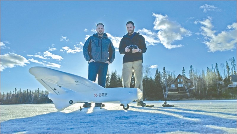
Thomas Stanley-Jones and Peter Dueck have launched Aerial Imaging Resources. AIR, as it’s known, offers high-resolution aerial maps and photos with the potential to expand into mineral surveying.
“We see a need and a uniqueness here in the North that makes this opportunity very interesting,” says Dueck.
Drone-based aerial imagery businesses similar to AIR have been popping up across Canada in recent years. Customers and potential customers run the gamut.
Corporations and municipalities may commission photographic maps of their boundaries. Film studios may call in search of aerial footage of a region. Real estate firms might want an overhead view of a property ready to hit the market.
With the use of a thermal camera, drones can be deployed to pinpoint where a warehouse is losing all that heat on its soaring electricity bill.
AIR has even been hired to produce photos that provide an accurate cattle count on a Saskatchewan feed lot.
Stanley-Jones agrees there are likely applications for the technology that he and Dueck haven’t even thought of yet.
As AIR takes off, the entrepreneurs are still considering what the most viable uses of drone-based imagery may be in this region.
Their guess is that the most demand will come from risky or labour-intensive jobs companies must perform, such as power-line inspections or mapping a tailings pond.
The foundation of AIR is a fleet of four remote-controlled drones, or unmanned aerial vehicles. The largest is an airplane-style unit with a two-metre wingspan; the smallest measures about 20 inches in diameter and is crowned with four propellers.
The drones can be flown manually or in automatic mode, but under federal regulations can never leave the operator’s sightline.
Once in the air, the drones snap a series of photos, back and forth in a grid pattern. The photos are electronically combined to form a single 3D image that details elevation differences.
Drone-based aerial imagery businesses have been popping up across Canada in recent years, but AIR hopes to corner the market in northern Manitoba and Saskatchewan.
Dueck says AIR takes into account the challenges of flying drones in the wilderness-rich region.
“An interesting challenge is the local tree coverage in the area,” he says. “For this reason, our fixed wing platform has a parachute deployment system which allows us to land in densely forested areas. Southern operators literally need areas the size of farmer’s fields to take off and land successfully. So although the competition in this industry is increasing exponentially in other jurisdictions, very few companies could successfully operate in the North.”
Stanley-Jones, a pilot originally from the US, has been aware of the drone-based imagery industry for several years. Nearly two years ago, he approached Dueck, a geophysicist, about partnering to build AIR.
Dueck was game, and the pair spent more than a year obtaining Transport Canada certification, acquiring equipment and conducting testing. AIR incorporated in early 2016.
“It proved much more difficult than anticipated at first, but we think it will still work out well,” says Stanley-Jones.
For Flin Flonners, perhaps one of the more exciting possibilities of drone technology relates to mineral prospecting. That potential is not lost on Stanley-Jones and Dueck.
AIR is planning trials to see how useful drones can be in the search for mineral riches. This will include testing the possibility of drone-based magnetic surveys.
Stanley-Jones expects that within a couple of years, companies will begin deploying drones, rather than helicopters, equipped with electromagnetic hoops for surveying purposes.
He sees other possibilities for drones in the mining industry.
“Once a mine is found, you can use [drones] for fast and accurate stockpile measurements or tailings pond mapping,” says Stanley-Jones. “Then when the mine has been depleted, [drones] can help with reclamation and ensure that companies are leaving our North pristine. In all of these cases they allow the job to be done better.”


