Thought the north was done with forest fire season? Not quite yet, if recent satellite images and data is to be believed.
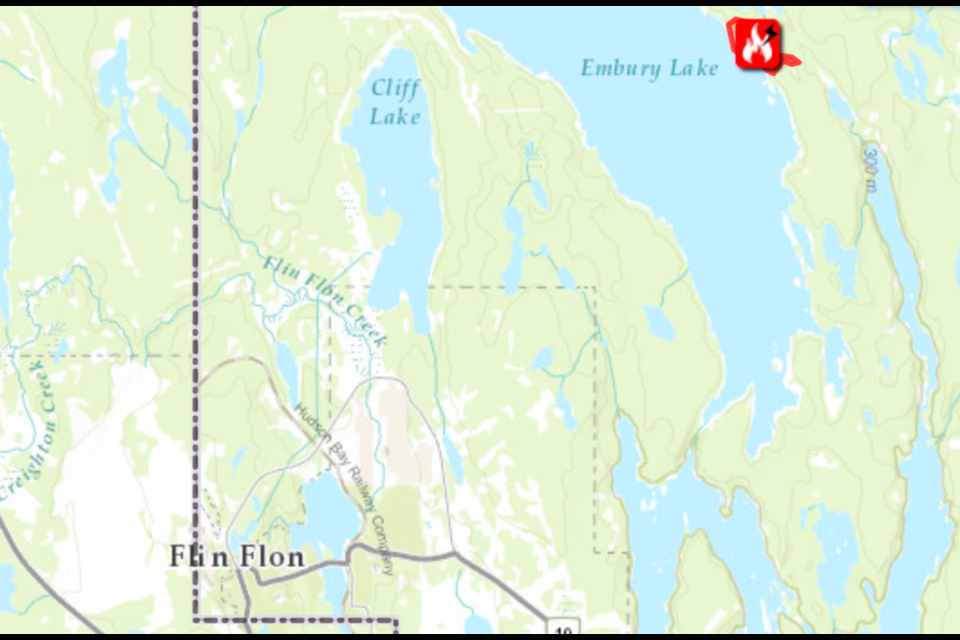
On the Manitoba side, a new fire developed over the weekend on the east shore of Trout Lake (or Embury Lake, as it is known officially). That fire, deemed by Manitoba Conservation and Climate to have been naturally caused, is at 20 hectares in size as of Oct. 6. Manitoba Conservation and Climate has marked the fire as "out of control" and are undertaking what they call a "full" response on the fire.
At its closest point, the fire - officially called the WE095 fire - is seven kilometres from Flin Flon, but several lakes (including Trout/Embury Lake) are between the fire and the Flin Flon/Creighton area.
In Saskatchewan, several hotspots have been picked up over the past week through satellite imagery and monitoring around the site of the ALIR fire. According to the Fire Information for Resource Management System (FIRMS), dozens of hotspots near areas impacted by the fire have popped up in the last week, despite the fire being officially described by the Saskatchewan Public Safety Agency (SPSA) as “out”.
The hotspots have appeared mostly in four isolated areas around the fire’s known perimeter - one southwest of Neagle Lake, another along the Sturgeon Weir River west of Amisk Lake, one in muskeg north of the river and due west of Amisk Lake and a final hotspot along Usinne Lake, southwest of Amisk Lake.
In a statement to The Reminder, a spokesperson from the SPSA confirmed that no agency resources are currently in use relating to the ALIR fire, but that it was under monitoring.
“The SPSA continues to monitor and detect fires as the warm weather extends into the fall. There are currently no response resources at the fire in question, however, we continue to monitor the area and will respond as necessary,” reads a statement from the spokesperson.
Most SPSA personnel in the Denare Beach fire protection area, who work seasonally, were laid off last month. Some have been contacted to return to work, but for firefighting efforts on fires near Hudson Bay, not on the ALIR fire. The ALIR fire was officially marked as “out” Sept. 20, not long after the seasonal layoffs.
Elsewhere in the region, a series of new hotspots have been found with the Noman fire near Mossy River, which is also considered “out” by the SPSA.
Meanwhile, most of the remaining SPSA resources are being sent to fight fires in the Hudson Bay fire protection area, where several fires are still burning with five still considered “not contained” by the agency. The largest, the Bell fire, is still burning as of Oct. 6 and has combined with a smaller fire - the two have combined to burn more than 84,000 hectares.
The fire has grown to such an extent that two nearby First Nations have evacuated people to larger centres further away from the blazes. The Shoal Lake Cree Nation, based out of Pakwaw Lake, evacuated over 400 people to Prince Albert, the second such evacuation the community has faced this year. About 200 people in Red Earth Cree Nation have been evacuated from the area to Regina and Saskatoon, due largely to worries about heavy smoke. Recent hotspots for the fire show it making its way north, toward both communities and Highway 55.
The remaining fires still considered active in Saskatchewan are burning in western Saskatchewan, near the Alberta border.
There are, as of Oct. 6, 13 active fires burning in Saskatchewan. Over 600 fires have been reported since the start of the summer.
Elsewhere in northern Manitoba, three main fires in the area near Pukatawagan, Sherridon and Snow Lake are remain under various levels of control. The WE064 fire south of Pukatawagan, which has burned nearly 54,000 hectares of land, is now considered to be “under control” by Manitoba Conservation and Climate as of Oct. 6. The WE032 fire, north of Snow Lake and east of Sherridon, is now considered as “being held” by Manitoba Conservation and Climate after having burned more than 64,000 hectares of land, while the WE049 fire burning near Highrock Lake is now being “monitored” with regional crews using what is considered to be a “modified” response.
Fire danger is being listed as “extreme” for much of southern Manitoba and Saskatchewan according to Natural Resources Canada as of Oct. , with most areas north of Nipawin and Hudson Bay seeing more favourable conditions. Denare Beach, Creighton, Pelican Narrows, Sandy Bay, The Pas, Cumberland House and other communities in both provinces are under a “high” fire danger rating, while Flin Flon itself, along with Cranberry Portage, Snow Lake, Sherridon and Pukatawagan, are all listed at a “medium” fire danger reading.


