The ALIR fire is continuing its move north, having now impacted almost 30,000 hectares of forest on Amisk Lake’s west shore. The fire is now growing closer to the Hanson Lake Road - Saskatchewan Highway 106. The fire is still being considered “out of control” by the Saskatchewan Public Safety Agency (SPSA).
New hotspots have been reported around the fire’s northernmost tip, along with areas stretching near the Sturgeon Weir River. At its closest point, the fire is less than four kilometres away from Highway 106 and gaining.
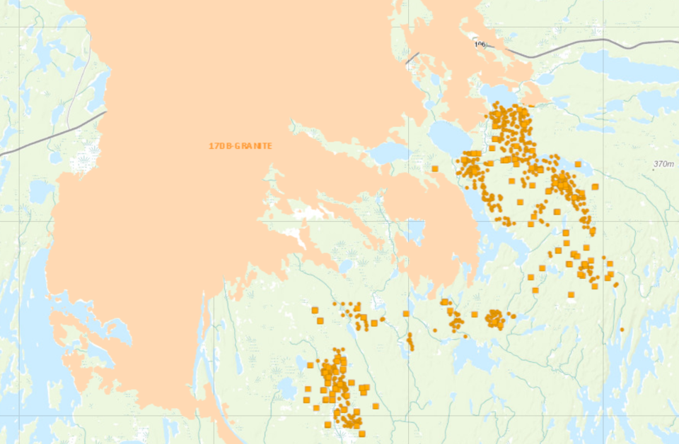
The most direct route toward the highway may not be likely for the ALIR fire - standing between the road and the blaze is a tract of land already burned back in 2017, when the Granite fire burned both sides of the road and ripped through the brush all around the highway. That fire, which reached 340,000 hectares, stretched as far north as MacLean Lake and further south past Attree Lake.
The ALIR fire is also about seven kilometres away from Birch Portage and Waskwaynikapik, a pair of Peter Ballantyne Cree Nation (PBCN) reserve communities along the Sturgeon Weir river north of the highway. The area was evacuated during the Granite fire four summers ago. No word of possible evacuation or preparation has yet been made public.
No injuries have been reported and no structures have been burned as a result of the ALIR fire as of Sept. 1.
Elsewhere in northern Saskatchewan, the Hobb fire, which was previously listed by the SPSA as “contained”, has been changed to “ongoing assessment”, with the fire having burned about 3,800 hectares of land. The fire is burning within 10 kilometres of Foran Mining’s McIlvenna Bay property.
The Fitz fire, which is burning north of Cotteral Lake, is now listed as “ongoing assessment” and has affected 109 hectares of area, including some new hotspots toward the fire’s northern tip.
Manitoba
Meanwhile, a pair of fires burning near Snow Lake, Pukatawagan and Sherridon are gathering steam.
New hotspots have been found with the WE032 and WE064 fires, with hotspots for both fires heading towards each other. The WE032 fire has now affected over 68,000 hectares, according to Natural Resources Canada, burning directly to the west, about 30 kilometres east of Sherridon and 25 kilometres north of Snow Lake. Some of the fire’s hotspots around Burntwood Lake are reported near recent hotspots for the WE064 fire - the two are about 15 kilometres apart at their closest points.
The WE064 fire has hit more than 60,000 hectares in size as of Sept. 1, with hotspots also being reported at its northern tip. That is not good news for Pukatawagan, which is located between 10-15 kilometres away from the fire’s northern tip and the location of those hotspots.
Both fires are considered “out of control” by Manitoba Conservation and Climate as of Sept. 1. The WE032 fire is considered to be under a “full” response by the group, while the WE064 fire is being “monitored”.
All areas near Flin Flon, including in Manitoba and Saskatchewan, are listed as having a "low" fire danger by Natural Resources Canada as of Sept. 1.


